Current hours: 10:30am to 5pm Tuesday through Saturday. We are closed Sundays and Mondays for the Winter. IMPORTANT PLEASE NOTE: We have become aware that some of our photos have been stolen by other websites. Our maps are only available at our website www.mapsofantiquity.com or at our store!

Genuine-Antique-Map-Great-Lakes-Partie-Occidentale-de-la-Nouvelle-France-ou-du-Canada-1755-Bellin-Homann-Heirs-Maps-Of-Antiquity
1755 - Great Lakes - Partie Occidentale de la Nouvelle France ou du Canada - Antique Map
  • Load image into Gallery viewer, Genuine-Antique-Map-Great-Lakes-Partie-Occidentale-de-la-Nouvelle-France-ou-du-Canada-1755-Bellin-Homann-Heirs-Maps-Of-Antiquity
  • Load image into Gallery viewer, 1755 - Great Lakes - Partie Occidentale de la Nouvelle France ou du Canada - Antique Map
  • Load image into Gallery viewer, 1755 - Great Lakes - Partie Occidentale de la Nouvelle France ou du Canada - Antique Map

1755 - Great Lakes - Partie Occidentale de la Nouvelle France ou du Canada - Antique Map

Regular price
$1,500.00
Sale price
$1,500.00
Regular price
Sold out
Unit price
per 
Shipping calculated at checkout.
 More payment options

Pickup available at 1409 MAIN ST, CHATHAM MA

Usually ready in 24 hours

Item number: CSMT175
Genuine Antique Map

1755

Maker: Bellin / Homann Heirs

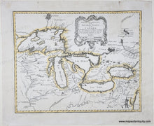
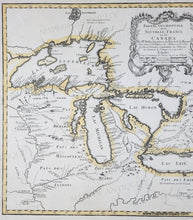
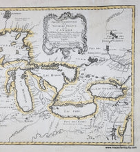
Antique map of the Great Lakes, first published by Bellin and reissued by Homann Heirs, 1755. This map clearly demonstrates how important rivers and waterways were for early exploration of North America. Includes forts, missions, villages, and some eastern cities. The label Checagou appears on the map near the location of Chicago. Though Bellin made every attempt to present verified information, the phantom islands found in Lake Superior would persist on maps into the early 19th century. The French gave considerably more respect and attention to the lands of the Native American tribes than other European cartographers of the period, noting the locations of the Iroquois, Eries, Miamis, Nipissings, and more. Good antique condition with some water stains in the upper corners and at bottom center, some other minor stains in the margins and a hole in the upper margin that was repaired. Measures approx. 16.5 x 21 inches to the neatline.

Genuine Antique Map from 1755

Item Number: CSMT175