Current hours: 10:30am to 5pm Tuesday through Saturday. We are closed Sundays and Mondays for the Winter. IMPORTANT PLEASE NOTE: We have become aware that some of our photos have been stolen by other websites. Our maps are only available at our website www.mapsofantiquity.com or at our store!

Genuine-Antique-Map-Rome-Il-Sito-della-citta-di-Roma-il-qual-quella-ha-questo-anno-di-Christo-1549-1550-Munster-Maps-Of-Antiquity
1550 - Rome - Il Sito della citta di Roma, il qual quella ha questo anno di Christo 1549 - Antique Map
  • Load image into Gallery viewer, Genuine-Antique-Map-Rome-Il-Sito-della-citta-di-Roma-il-qual-quella-ha-questo-anno-di-Christo-1549-1550-Munster-Maps-Of-Antiquity
  • Load image into Gallery viewer, 1550 - Rome - Il Sito della citta di Roma, il qual quella ha questo anno di Christo 1549 - Antique Map

1550 - Rome - Il Sito della citta di Roma, il qual quella ha questo anno di Christo 1549 - Antique Map

Regular price
$650.00
Sale price
$650.00
Regular price
Sold out
Unit price
per 
Shipping calculated at checkout.
 More payment options

Pickup available at 1409 MAIN ST, CHATHAM MA

Usually ready in 24 hours

Item number: CSMT195
Genuine Antique Map

1550

Maker: Munster

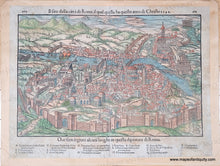
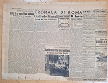
Antique map of Rome, Italy, by Sebastian Munster, c. 1550. Early view of 16th century Rome and the Vatican City with its churches, universities and palaces keyed to a legend at bottom. Monuments of the ancient city, such as the Colosseum, the Pantheon and the aqueducts are also shown. This is one of the earliest obtainable views of Rome. This map is affixed to a board. On the other side of the board is newsprint from Rome, September 9, 1941. Fair to good antique condition. Imperfect printing on left side. Some tears at the edges and some paper loss in the lower right. Minor toning/stains. Measures approx. 9.25 x 14.25 inches to the neatline and approx. 11.5 x 15.25 inches to the paper edges (not including the board it is attached to).

Genuine Antique Map from 1550

Item Number: CSMT195