1930s
Maker: Marguerite Gillespie
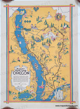
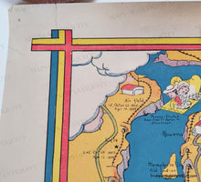
Antique pictorial map showing the Mount Hoop Loop in Oregon. This map was made by Marguerite Gillespie, published by the Beaver Engraving Company, and is undated, but likely 1930s based on the styles of dress, hair, and automobile in the map. This map shows Portland in the lower right and the roads and railroads that travel the area, including the Mount Hood Loop, which follows the Columbia River before looping around Mount Hood. Humorous illustrations are scattered throughout the map showing people enjoying their recreation, whether on a tour bus, hiking, golfing, hunting, or simply taking in the sights from the road. Very good antique condition with some pin holes in the corners, some minor wear in the margins, and a small tear in the upper left corner. This map was rolled and retains some curl, although it is currently packaged flat to reduce the roll. Measures approx. 21.25 x 15.5 inches to the paper edges. This rare map has not been seen on the market in many years. There is one other known example in the Yale Library collection.
"In 1911 E. Henry Wemme, an automobile enthusiast and Portland businessman, purchased the old road from the Mount Hood & Barlow Road Company with the intentions of improving the route to the mountain and points east for the automobile that was to become the new wave of modern transportation. Two years later he offered the road to the government, who turned down his offer. He died the following year and willed the road to his attorney, who in 1917 presented it to the state who removed the tolls on the road and took over maintenance. By that time there had already been talk of plans for a road that would allow travel completely around Mount Hood.... In 1919 a cooperative agreement was signed between the state and the government to build the road. It was started late in the year of 1919, and was completed in late 1924. The first traffic to follow the new road came in the summer of 1925 after the winter snows cleared." (from mounthoodhistory.com).
Genuine Antique Map from 1930s
Item Number: CSMT211


