Winter hours: Tuesday - Saturday 10am to 5pm. Close Sundays and Mondays until May. We appreciate your business!

Genuine-Antique-Folding-Map-Deutsches-Reich-nebst-Deutsch-Osterreich-und-Schweiz-Europe-Germany-c.-1890-Carl-Flemming-Maps-Of-Antiquity-1800s-19th-century
1890 - Deutsches Reich nebst Deutsch-Osterreich und Schweiz - Antique Map
  • Load image into Gallery viewer, Genuine-Antique-Folding-Map-Deutsches-Reich-nebst-Deutsch-Osterreich-und-Schweiz-Europe-Germany-c.-1890-Carl-Flemming-Maps-Of-Antiquity-1800s-19th-century
  • Load image into Gallery viewer, 1890 - Deutsches Reich nebst Deutsch-Osterreich und Schweiz - Antique Map
  • Load image into Gallery viewer, 1890 - Deutsches Reich nebst Deutsch-Osterreich und Schweiz - Antique Map

1890 - Deutsches Reich nebst Deutsch-Osterreich und Schweiz - Antique Map

Regular price
$250.00
Sale price
$250.00
Regular price
Sold out
Unit price
per 
Shipping calculated at checkout.

Item number: EUR2756
Genuine Antique Folding Map

c. 1890

Maker: Carl Flemming.

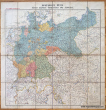
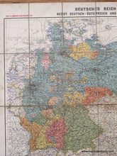
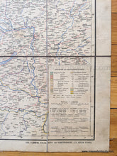
Antique printed color folding map of Germany with Austria and Switzerland, by Carl Flemming, c. 1890. Includes cities, towns, railroads, canals, telegraph lines, and more. Made before cars were common, there limited roads indicated. This map is 24 printed paper panels mounted on fabric (possibly silk or light-weight linen). Very good condition with mild stains/soiling. Good color and should frame nicely. Comes folded in a case. Map measures approx. 25.25 x 25.25 inches to the neatline or 28 x 27.5 inches to the edges.

Item Number: EUR2756