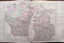
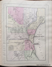
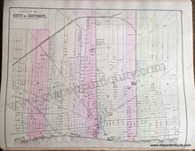
Antique-Hand-Colored-Map-Double-sided-sheet-with-multiple-maps:-Centerfold---County-and-Township-Map-of-the-States-of-Michigan-and-Wisconsin;-versos:-Plan-of-Milwaukee-/-Plan-of-the-City-of-Detroit-United-States-Midwest-1884-Mitchell-Maps-Of-Antiquity-1800s-19th-century
1884 - Double-sided sheet with multiple maps: Centerfold - County and Township Map of the States of Michigan and Wisconsin; versos: Plan of Milwaukee / Plan of the City of Detroit - Antique Map
  • Load image into Gallery viewer, Antique-Hand-Colored-Map-Double-sided-sheet-with-multiple-maps:-Centerfold---County-and-Township-Map-of-the-States-of-Michigan-and-Wisconsin;-versos:-Plan-of-Milwaukee-/-Plan-of-the-City-of-Detroit-United-States-Midwest-1884-Mitchell-Maps-Of-Antiquity-1800s-19th-century
  • Load image into Gallery viewer, 1884 - Double-sided sheet with multiple maps: Centerfold - County and Township Map of the States of Michigan and Wisconsin; versos: Plan of Milwaukee / Plan of the City of Detroit - Antique Map
  • Load image into Gallery viewer, 1884 - Double-sided sheet with multiple maps: Centerfold - County and Township Map of the States of Michigan and Wisconsin; versos: Plan of Milwaukee / Plan of the City of Detroit - Antique Map

1884 - Double-sided sheet with multiple maps: Centerfold - County and Township Map of the States of Michigan and Wisconsin; versos: Plan of Milwaukee / Plan of the City of Detroit - Antique Map

Regular price
$125.00
Sale price
$125.00
Regular price
Sold out
Unit price
per 
Shipping calculated at checkout.

Item number: MWE483
Genuine Antique Hand Colored Map

1884

Maker: Mitchell.

Antique hand colored maps from Mitchell's 1884 New General Atlas. The Centerfold map shows the states of Michigan and Wisconsin, colored by county, showing railways, political boundaries, cities, water bodies, as well as land features. Includes towns with names. On the back side is a map of Milwaukee on one side, and a map of Detroit on the other side. City maps show roads, railways, bodies of water, notable buildings, etc. This map is in very good antique condition with minor overall toning. Paper is a bit fragile. Centerfold map measures approximately 14.25 x 21 inches to the outer neatline. Milwaukee map measures approx. 13.5 x 10 inches to the outer neatline. Detroit map measures approx. 11 x 13.75 inches to the outer neatline. Each city map can be purchased separately for $75

Item Number: MWE483