Current hours: 10am to 5pm Monday through Saturday. 12pm to 5pm Sundays. IMPORTANT PLEASE NOTE: We have become aware that some of our photos have been stolen by other websites. Our maps are only available at our website www.mapsofantiquity.com or at our store!

Genuine-Antique-Map-French-Alps-La-Savoye-Dediee-au-Roy-1782-Placide-Dezauche-Maps-Of-Antiquity
Genuine-Antique-Map-French-Alps-Lake-Geneva-Chamonix-Mont-BlancLa-Savoye-Dediee-au-Roy-1782-Placide-Dezauche-Maps-Of-Antiquity
  • Load image into Gallery viewer, Genuine-Antique-Map-French-Alps-La-Savoye-Dediee-au-Roy-1782-Placide-Dezauche-Maps-Of-Antiquity
  • Load image into Gallery viewer, Genuine-Antique-Map-French-Alps-Lake-Geneva-Chamonix-Mont-BlancLa-Savoye-Dediee-au-Roy-1782-Placide-Dezauche-Maps-Of-Antiquity

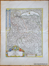
1782 - La Savoye, Dediee au Roy (French Alps) - Antique Map

Regular price
$425.00
Sale price
$425.00
Regular price
Sold out
Unit price
per 
Shipping calculated at checkout.

Item number: EUR3049
Genuine Antique Map

1782

Maker: Placide / Dezauche


Antique map of part of south-eastern France, by Placide, published by Dezauche, successor to De l'Isle, 1782. This map includes Lake Geneva at top, with the French Alps, Chamonix, Moutiers, and many more towns and cities, some roads, with mountains named and unnamed, including Mont Blanc. The first recorded ascent of Mont Blanc (at the time neither within Italy nor France) was on 8 August 1786 by Jacques Balmat and the doctor Michel Paccard. This climb, initiated by Horace-Bénédict de Saussure, who gave a reward for the successful ascent, traditionally marks the start of modern mountaineering. The first woman to reach the summit was Marie Paradis in 1808. This handsome map features a decorative cartouche, scale of miles, and description, and a compass rose in Lake Geneva. Very good antique condition with a few small spots mostly in the margin. With a fold as issued. Measures approx. 22.5 x 16.75 inches to the neatline.


Item Number: EUR3049