Current hours: 10am to 5pm Monday through Saturday. Closed on Sundays. PLEASE NOTE: Our maps are only available at our website www.mapsofantiquity.com or at our store!

Antique-Printed-Color-Pictorial-Folding-Map-Georgia-Alabama-Road-Map-with-Pictorial-Guide-to-Georgia-and-Alabama-1949-Standard-Oil-Company-Georgia-Alabama-1800s-19th-century-Maps-of-Antiquity
1949 - Georgia Alabama Road Map with Pictorial Guide to Georgia and Alabama - Antique Pictorial Map
  • Load image into Gallery viewer, Antique-Printed-Color-Pictorial-Folding-Map-Georgia-Alabama-Road-Map-with-Pictorial-Guide-to-Georgia-and-Alabama-1949-Standard-Oil-Company-Georgia-Alabama-1800s-19th-century-Maps-of-Antiquity
  • Load image into Gallery viewer, 1949 - Georgia Alabama Road Map with Pictorial Guide to Georgia and Alabama - Antique Pictorial Map
  • Load image into Gallery viewer, 1949 - Georgia Alabama Road Map with Pictorial Guide to Georgia and Alabama - Antique Pictorial Map

1949 - Georgia Alabama Road Map with Pictorial Guide to Georgia and Alabama - Antique Pictorial Map

Regular price
$45.00
Sale price
$45.00
Regular price
Sold out
Unit price
per 
Shipping calculated at checkout.

Item number: SOU424
Genuine Antique Printed Color Pictorial Folding Map

1949

Maker: Standard Oil Company.

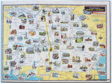
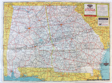
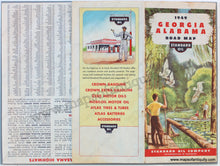
Antique printed color folding road map of Georgia and Alabama, with smaller maps on verso showing the Principal Highways of North and South Carolina, the cities of Atlanta and Birmingham, and a Pictorail Guide to Georgia and Alabama, as well as a few reference charts with regional information. With folds, as issued. Good to Very good overall antique condition with mild toning and wrinkling throughout, as well as a few areas of seam separation at the fold intersections. Road Map on recto measures approximately 19" x 25.75" (H x W) to the neatline. Pictorial map on verso measures approx. 8.25" x 11.5" to the neatline.

Item Number: SOU424