Current hours: 10am to 5pm Monday through Saturday. 12pm to 5pm Sundays. We are CLOSED on Christmas Day and New Years Day. We will close early (3pm) on Christmas Eve. IMPORTANT PLEASE NOTE: We have become aware that some of our photos have been stolen by other websites. Our maps are only available at our website www.mapsofantiquity.com or at our store!

Antique-Hand-Colored-Map-Ipswich-Rowley-and-Wenham-Massachusetts-**********-United-States-Massachusetts-1884-Walker-Maps-Of-Antiquity
1884 - Ipswich Rowley And Wenham Massachusetts Antique Map Genuine Hand-Colored
  • Load image into Gallery viewer, Antique-Hand-Colored-Map-Ipswich-Rowley-and-Wenham-Massachusetts-**********-United-States-Massachusetts-1884-Walker-Maps-Of-Antiquity
  • Load image into Gallery viewer, 1884 - Ipswich Rowley And Wenham Massachusetts Antique Map Genuine Hand-Colored
  • Load image into Gallery viewer, 1884 - Ipswich Rowley And Wenham Massachusetts Antique Map Genuine Hand-Colored

1884 - Ipswich, Rowley, and Wenham, Massachusetts - Antique Map

Regular price
$150.00
Sale price
$150.00
Regular price
Sold out
Unit price
per 
Shipping calculated at checkout.

Item number: MAS1652
Genuine Antique Hand-colored Map

1884

Maker: Walker.


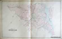
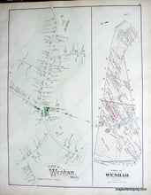
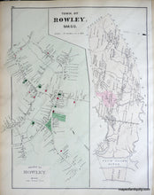
Antique hand-colored maps of Ipswich, Rowley, and Wenham, MA from Walker's 1884 Atlas of Essex County. The large center-fold map is the town of Ipswich and shows property owners buildings and names, bodies of water, landforms, islands, railroads, roads, and lighthouses. Side two displays the town of Rowley with the village of Rowley and side three is the Town of Wenham with the village of Wenham. Includes buildings with owners names, public buildings and areas, landforms, bodies of water, islands, railroads, roads, and schools. Very good overall antique condition with light overall toning and some small tears at the paper edges. Total page size approx. 17 x 26 inches. 


Item Number: MAS1652