Pickup available at 1409 MAIN ST, CHATHAM MA
Usually ready in 24 hours
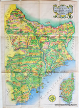
1948 - French Riviera - La Cote d'Azur, la Principaute de Monaco, et la Corse - Antique Pictorial Map
-
1409 MAIN ST, CHATHAM MA
Pickup available, usually ready in 24 hours1409 Main Street
Chatham MA 02633
United States+15089451660
1948
Maker: O. Poissons.
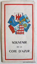
Antique pictorial map of the Cote d'Azur or French Riviera with Monaco and Corsica by O. Poissons, 1948. With cities and towns labeled, including Cannes, Nice, Antibes, Grasse, and more. Shows roads with illustrated towns, topography, people engaged in activities, animals, and more. The decorative cartouche features a double-tailed mermaid and merman. This is a folding map and it is still attached to its original paper jacket, which can be folded under to frame. Very good antique condition with mild toning and slight wear along the folds. Folds as issued. Approx. 23.75 x 16.5 inches to the neatline.
Item Number: EUR2523


