Current hours: 10am to 5pm Monday through Saturday. 12pm to 5pm Sundays. IMPORTANT PLEASE NOTE: We have become aware that some of our photos have been stolen by other websites. Our maps are only available at our website www.mapsofantiquity.com or at our store!

Lake-Winnipesaukee-New-Hampshire
Lake Winnipesaukee, New Hampshire - Reproduction -
  • Load image into Gallery viewer, Lake-Winnipesaukee-New-Hampshire
  • Load image into Gallery viewer, Lake Winnipesaukee, New Hampshire - Reproduction -
  • Load image into Gallery viewer, Lake Winnipesaukee, New Hampshire - Reproduction -
  • Load image into Gallery viewer, Lake Winnipesaukee, New Hampshire - Reproduction -
  • Load image into Gallery viewer, Lake Winnipesaukee, New Hampshire - Reproduction -

Lake Winnipesaukee, New Hampshire - Reproduction -

Regular price
$75.00
Sale price
$75.00
Regular price
Sold out
Unit price
per 
Shipping calculated at checkout.

Item number: REP286

Reproduction

Reproduction

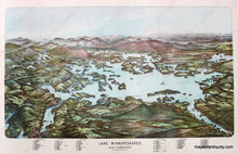
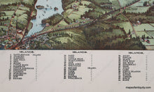
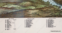
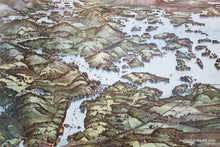
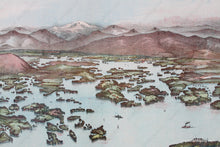
Graphically stunning and rare 1903 Walker bird's-eye view map reproduced as limited edition High-quality print of Lake Winnipesaukee, includes and index and notation on the map of key islands and mountains of the region. Print includes views of the White Mountains in the background with Mt. Washington in the center with snow. Many NH islands, towns and bays are shown including, Center Harbor, Asquam, Motonboro, Gilford, Wolfboro, Lake Wenworth, Lake Ossipee, Long Bay, Meredith Bay, Alton Bay, Lake Shore Branch of the B & M Railroad, Tufonboro, Melvin Village and White Face Mountain. Approximately 16" x 28". Measured to the edges of the printed area. Paper may be larger but can be trimmed as needed.


Item Number: REP286