Current hours: 10am to 5pm Monday through Saturday. 12pm to 5pm Sundays. IMPORTANT PLEASE NOTE: We have become aware that some of our photos have been stolen by other websites. Our maps are only available at our website www.mapsofantiquity.com or at our store!

Printed-Color-Antique-Map-Lyons-France-Europe-France-c.-1947-French-Ministry-of-Travel-Maps-Of-Antiquity
1947 - Lyons, France - Antique Map
  • Load image into Gallery viewer, Printed-Color-Antique-Map-Lyons-France-Europe-France-c.-1947-French-Ministry-of-Travel-Maps-Of-Antiquity
  • Load image into Gallery viewer, 1947 - Lyons, France - Antique Map
  • Load image into Gallery viewer, 1947 - Lyons, France - Antique Map
  • Load image into Gallery viewer, 1947 - Lyons, France - Antique Map

1947 - Lyons, France - Antique Map

Regular price
$75.00
Sale price
$75.00
Regular price
Sold out
Unit price
per 
Shipping calculated at checkout.

Item number: EUR1337
Printed Color Genuine Antique Map

c. 1947

Maker: French Ministry of Travel.

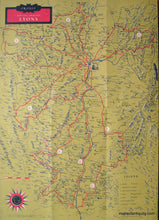
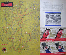
Antique printed color folding tourist map of the area around Lyon, France, published by the French Ministry of Travel, in English, including Grenoble, Valence, Vichy, and Cluny, with major points of interest including a key to major roads, castles, churches, ruins, etc., verso features narrative of the area and photographs of famous tourist attractions with suggested driving routes, c. 1947. Very good condition with vivid original color, measures approx. 17.5 x 20.5 inches unfolded, map only measures 17.5 x 12.5.

Item Number: EUR1337