Winter hours: Tuesday - Saturday 10am to 5pm. Close Sundays and Mondays until May. We appreciate your business!

Antique-Hand-Colored-Map-Map-of-Alexander-&-Pulaski-Counties;-verso:-Four-small-cities-of-Illinois-1876-Warner-&-Beers-/-Union-Atlas-Co.-Midwest-1800s-19th-century-Maps-of-Antiquity
1876 - Map of Alexander & Pulaski Counties; verso: Four small cities of Illinois - Antique Map
  • Load image into Gallery viewer, Antique-Hand-Colored-Map-Map-of-Alexander-&-Pulaski-Counties;-verso:-Four-small-cities-of-Illinois-1876-Warner-&-Beers-/-Union-Atlas-Co.-Midwest-1800s-19th-century-Maps-of-Antiquity
  • Load image into Gallery viewer, 1876 - Map of Alexander & Pulaski Counties; verso: Four small cities of Illinois - Antique Map

1876 - Map of Alexander & Pulaski Counties; verso: Four small cities of Illinois - Antique Map

Regular price
$65.00
Sale price
$65.00
Regular price
Sold out
Unit price
per 
Shipping calculated at checkout.

Item number: MWE423
Genuine Antique Printed Color Map

1876

Maker: Warner & Beers / Union Atlas Co..

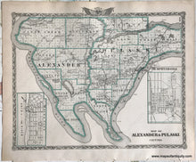
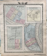
Antique double-sided map: on one side is a map of Alexander & Pulaski conuties; on the other side are four maps of cities including Metropolis, Pinckneyville, Shawneetown, and Cairo, IL. Inset maps of Mound City and Murphysboro. Published in the Atlas of the State of Illinois, published by Warner & Beers with the Union Atlas Co., 1876. Good to very good condition, with some minor spots and overall mild toning that is a bit darker at the paper edge. Counties map measure approx.12.5 x 16 inches to the neatline, not including the decorative border. Cities maps measure approx. 15 x 12 inches to the neatline, not including the decorative border.

Item Number: MWE423