Current hours: 10am to 5pm Tuesday through Saturday. We are closed Sundays and Mondays until late May. Proud to be a SMALL, LOCAL, CAPE COD BUSINESS! Maps of Antiquity is in its 38th year! Our maps are only available at our website www.mapsofantiquity.com or at our store!

Colored-Antique-Folding-Map-Map-of-Boston-and-Surroundings-Massachusetts-Boston-c.-1910-Walker-Maps-Of-Antiquity
1910 - Map Of Boston And Surroundings Antique Colored Genuine Folding
  • Load image into Gallery viewer, Colored-Antique-Folding-Map-Map-of-Boston-and-Surroundings-Massachusetts-Boston-c.-1910-Walker-Maps-Of-Antiquity
  • Load image into Gallery viewer, 1910 - Map Of Boston And Surroundings Antique Colored Genuine Folding
  • Load image into Gallery viewer, 1910 - Map Of Boston And Surroundings Antique Colored Genuine Folding
  • Load image into Gallery viewer, 1910 - Map Of Boston And Surroundings Antique Colored Genuine Folding
  • Load image into Gallery viewer, 1910 - Map Of Boston And Surroundings Antique Colored Genuine Folding

1910 - Map of Boston and Surroundings - Antique Map

Regular price
$250.00
Sale price
$250.00
Regular price
Sold out
Unit price
per 
Shipping calculated at checkout.

Item number: MAS1695
Colored Genuine Antique Folding Map

c. 1910

Maker: Walker.

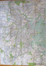
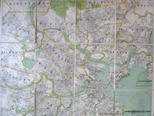
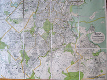
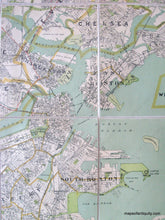
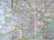
Original color antique folding map of Boston and its surroundings by George H Walker of Boston, published circa 1910. Includes Blue Hills Reservations, Middlesex Fells Reservation, , Mystic River, Fresh Pond, streets, parks, ponds, bridges, buildings, government buildings and properties, lakes, cemeteries, roads, railways, land and water bodies, and more. Backed on linen. Very good overall antique condition. approx. 42 x 29 inches

Item Number: MAS1695