Current hours: 10:30am to 5pm Tuesday through Saturday. We are closed Sundays and Mondays for the Winter. IMPORTANT PLEASE NOTE: We have become aware that some of our photos have been stolen by other websites. Our maps are only available at our website www.mapsofantiquity.com or at our store!

Black-and-White-Engraving-Map-of-Deposit-Sanford-TP.--Broome-County-(NY)-United-States-New-York-1876-Everts-Ensign-&-Everts-Maps-Of-Antiquity
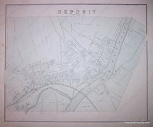
1876 - Map Of Deposit Sanford Tp. Broome County (Ny) Antique Genuine
  • Load image into Gallery viewer, Black-and-White-Engraving-Map-of-Deposit-Sanford-TP.--Broome-County-(NY)-United-States-New-York-1876-Everts-Ensign-&-Everts-Maps-Of-Antiquity
  • Load image into Gallery viewer, 1876 - Map Of Deposit Sanford Tp. Broome County (Ny) Antique Genuine

1876 - Map of Deposit, Sanford TP. Broome County (NY) - Antique Map

Regular price
$85.00
Sale price
$85.00
Regular price
Sold out
Unit price
per 
Shipping calculated at checkout.

Item number: NYO511
Genuine Antique Map

1876

Maker: Everts, Ensign, & Everts.


Antique map from the 1876 Broome County Atlas by Everts, Ensign & Everts. Double-sided. Reverse of page contains images of the residences of Patrick Mallery and The Smith Block. This piece measures approximate 15 x 12 inches and is in Very Good antique condition with some minor foxing and discoloration throughout.


Item Number: NYO511