Current hours: 10am to 5pm Tuesday through Saturday. We are closed Sundays and Mondays for the Winter. Proud to be a SMALL, LOCAL, CAPE COD BUSINESS! Maps of Antiquity is in its 38th year! Our maps are only available at our website www.mapsofantiquity.com or at our store!

Map-of-Mannington-Township-Map-of-Pittsgrove-Township-New-Jersey-NJ-Antique-Map-1876-Everts-Stewart-Maps-of-Antiquity-1870s-1800s-19th-century
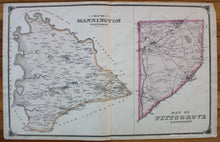
1876 - Map Of Mannington Township Pittsgrove (Nj) Antique Genuine Hand-Colored
  • Load image into Gallery viewer, Map-of-Mannington-Township-Map-of-Pittsgrove-Township-New-Jersey-NJ-Antique-Map-1876-Everts-Stewart-Maps-of-Antiquity-1870s-1800s-19th-century
  • Load image into Gallery viewer, 1876 - Map Of Mannington Township Pittsgrove (Nj) Antique Genuine Hand-Colored

1876 - Map of Mannington Township, Map of Pittsgrove Township (NJ) - Antique Map

Regular price
$115.00
Sale price
$115.00
Regular price
Sold out
Unit price
per 
Shipping calculated at checkout.

Item number: NJE244
Genuine Antique Hand Colored Map

1876

Maker: Everts & Stewart.

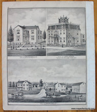
Antique hand colored map of Mannington Township and Pittsgrove Township in Salem County, New Jersey, from the New Historical Atlas of Salem & Gloucester Counties by Everts & Stewart, 1876. Shows major roads, railroads, bodies of water, village centers, buildings with property owners names, and more. Verso features three illustrations: "Residence of C.P. Atkinson, M.D.," "Residence of John Hanes," and "Residence of Coombs Ackley." Attractive decorative border. Good antique condition with overall toning, some minor stains, and some wear and tears at the paper edges. Should frame nicely. Approx. 16 x 25.25 inches to the neatlines.

Item Number: NJE244