1903
Maker: Cram.
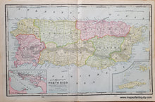
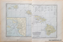
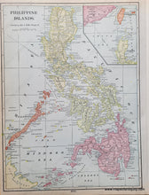
Antique printed color multi-sided map of the island of Puerto Rico with inset maps of San Juan Harbor, and Crab Island & Culebra Island (Recto.) Versos: Map of the Hawaiian Islands, with an inset map of Honolulu, and map of the Philippines. Maps include topographical detail, major cities/towns, etc. Good to very good overall antique condition with some mild toning throughout, some minor wear at paper edges. Hawaii map is printed on two pages that are slightly offset. Recto map (Puerto Rico) measures approximately 12.75" x 20.75" (H x W) to the neatline. Verso (Hawaiian Islands) measures approx. 11.5" x 17.5" to the neatline. Verso of Philippines measures approx. 13.75 x 10 inches.
Item Number: CAR022


