Current hours: 10am to 5pm Monday through Saturday. 12pm to 5pm Sundays. IMPORTANT PLEASE NOTE: We have become aware that some of our photos have been stolen by other websites. Our maps are only available at our website www.mapsofantiquity.com or at our store!

Antique-Map-Pictorial-tourist-Folding-Black-Hills-South-Dakota-1940
1940 - Map Of The Black Hills South Dakota The Sunshine State Antique Genuine Printed-Color
  • Load image into Gallery viewer, Antique-Map-Pictorial-tourist-Folding-Black-Hills-South-Dakota-1940
  • Load image into Gallery viewer, 1940 - Map Of The Black Hills South Dakota The Sunshine State Antique Genuine Printed-Color

1940 - Map of the Black Hills of South Dakota, The Sunshine State - Antique Map

Regular price
$110.00
Sale price
$110.00
Regular price
Sold out
Unit price
per 
Shipping calculated at checkout.

Item number: MWE357
Genuine Antique Printed Color Map

1940

Maker: Black Hills and Bad Lands Association.

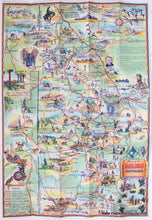
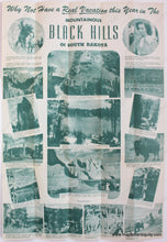
Antique printed color folding tourist map of part of South Dakota, published by the Black Hills and Bad Lands Association in 1940. This map was produced for free distribution and it includes towns and cities, major roads, various attractions, historical scenes, and more. The verso asks "Why Not Have a Real Vacation this Year in The Mountainous Black Hills of South Dakota" with photographs and captions. This map is in very good condition with folds as issued. Overall dimensions are approx. 26.5 x 18 inches.

Item Number: MWE357