Current hours: 10am to 5pm Tuesday through Saturday. We are closed Sundays and Mondays for the Winter. Proud to be a SMALL, LOCAL, CAPE COD BUSINESS! Maps of Antiquity is in its 38th year! Our maps are only available at our website www.mapsofantiquity.com or at our store!

Genuine-Antique-Printed-Color-Comparative-Chart-Maps-of-Europe-during-the-Roman-Empire-Ancient-World--1892-Home-Library-&-Supply-Association-Maps-Of-Antiquity-1800s-19th-century
1892 - Maps Of Europe During The Roman Empire Antique Chart Genuine Printed-Color Comparative
  • Load image into Gallery viewer, Genuine-Antique-Printed-Color-Comparative-Chart-Maps-of-Europe-during-the-Roman-Empire-Ancient-World--1892-Home-Library-&-Supply-Association-Maps-Of-Antiquity-1800s-19th-century
  • Load image into Gallery viewer, 1892 - Maps Of Europe During The Roman Empire Antique Chart Genuine Printed-Color Comparative

1892 - Maps of Europe during the Roman Empire - Antique Chart

Regular price
$50.00
Sale price
$50.00
Regular price
Sold out
Unit price
per 
Shipping calculated at checkout.

Item number: EUR2743
Genuine Antique Printed Color Comparative Chart

1892

Maker: Home Library & Supply Association.

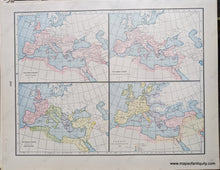
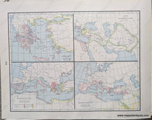
Antique printed color double-sided maps published in "The Pacific Coast and the World" by the Home Library and Supply Association, 1892. Maps include: The Roman Empire under Trajan, The Roman Empire at the Death of Augustus, The Roman Empire divided into Prefectures, Europe end of Seventh Century. Other side maps include: Homeric Greece, Kingdoms of the Successors of Alexander, The Mediterranean Lands at the Beginning of the Second Punic War, The Roman Dominions ath the end of the Mithridatic War. Very good overall antique condition with some very mild toning/foxing (mainly at the outer edges.) Measure approx. 12 x 9.25" to the neatline.

Item Number: EUR2743