Current hours: 10am to 5pm Monday through Saturday. 12pm to 5pm Sundays. IMPORTANT PLEASE NOTE: We have become aware that some of our photos have been stolen by other websites. Our maps are only available at our website www.mapsofantiquity.com or at our store!

Old-Printed-Color-Map-Geologic-Map-of-Cape-Cod-and-the-Islands-Massachusetts-1986-US-Geological-Survey-Maps-Of-Antiquity
  • Load image into Gallery viewer, Old-Printed-Color-Map-Geologic-Map-of-Cape-Cod-and-the-Islands-Massachusetts-1986-US-Geological-Survey-Maps-Of-Antiquity
  • Load image into Gallery viewer, Old-Printed-Color-Map-Geologic-Map-of-Cape-Cod-and-the-Islands-Massachusetts-1986-US-Geological-Survey-Maps-Of-Antiquity
  • Load image into Gallery viewer, Old-Printed-Color-Map-Geologic-Map-of-Cape-Cod-and-the-Islands-Massachusetts-1986-US-Geological-Survey-Maps-Of-Antiquity
  • Load image into Gallery viewer, Old-Printed-Color-Map-Geologic-Map-of-Cape-Cod-and-the-Islands-Massachusetts-1986-US-Geological-Survey-Maps-Of-Antiquity
  • Load image into Gallery viewer, Old-Printed-Color-Map-Geologic-Map-of-Cape-Cod-and-the-Islands-Massachusetts-1986-US-Geological-Survey-Maps-Of-Antiquity

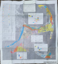
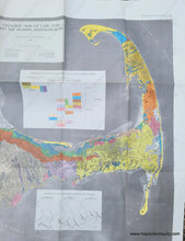
1986 - Geologic Map of Cape Cod and the Islands, Massachusetts - Vintage Map

Regular price
$125.00
Sale price
$125.00
Regular price
Sold out
Unit price
per 
Shipping calculated at checkout.

Item number: MAS2249
Old Printed Color Map

1986

Maker: US Geological Survey

Fantastic geologic map of Cape Cod, Martha's Vineyard, and Nantucket, published in 1986 by Robert Oldale and Roger Barlow for the Department of the Interior, U.S. Geological Survey. With a large descriptive key on the left side and an inset map showing the Ice Recession and Lobe Formation in the Cape Cod Area. Shows towns, roads, beaches, water, and more. Measures approx. 44 x 39 inches to the paper edges.

Item Number: MAS2249