1912
Maker: Bromley
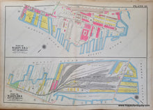
Antique map of part of Boston, published in the Atlas of the City of Boston, Charlestown and East Boston, From Actual Surveys and Official Plans by George W. and Walter S. Bromley, published by G.W. Bromley & Co., 1912. This map shows the area near the Charlestown Navy Yard at the top and the North part of Charlestown with South Channel (Little Mystic). North is not oriented directly up. Fair to good antique condition. Some mild toning and surface grime, tiny spots, small tears at paper edges, and pencil markings from a previous owner. Should look fine when framed. Measures approx. 20.25 x 30 inches to the neatline.
Item Number: MAS2416


