1912
Maker: Bromley
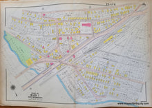
Antique map of part of Boston, published in the Atlas of the City of Boston, Charlestown and East Boston, From Actual Surveys and Official Plans by George W. and Walter S. Bromley, published by G.W. Bromley & Co., 1912. This map shows the area near Noyes Playground (which used to be right on the water before fill was added), with Bennington St, Gladston St, Satatoga St, and Washburn Ave. North is not oriented directly up. Fair to good antique condition. Some mild toning and surface grime, tiny spots, wear at paper edges that can be hidden with a mat when framing, and pencil markings from a previous owner. A previous owner seems to have folded this map in quarters, but the folds do not noticeably impact the map. Should look fine when framed. Measures approx. 20.25 x 30 inches to the neatline.
Item Number: MAS2428


