Current hours: 10am to 5pm Tuesday through Saturday. We are closed Sundays and Mondays until late May. Proud to be a SMALL, LOCAL, CAPE COD BUSINESS! Maps of Antiquity is in its 38th year! Our maps are only available at our website www.mapsofantiquity.com or at our store!

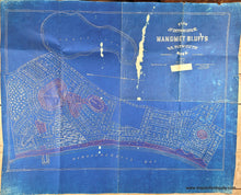
Blueprint style map with red markings showing part of Plymouth, MA. Genuine-Antique-Map-Plan-of-Cottage-Lots-at-Manomet-Bluffs-So-Plymouth-Mass--1920-Brine-Hugo-Bufford-Maps-Of-Antiquity
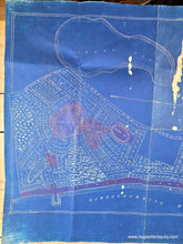
  • Load image into Gallery viewer, Blueprint style map with red markings showing part of Plymouth, MA. Genuine-Antique-Map-Plan-of-Cottage-Lots-at-Manomet-Bluffs-So-Plymouth-Mass--1920-Brine-Hugo-Bufford-Maps-Of-Antiquity
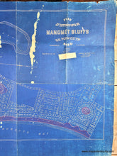
  • Load image into Gallery viewer, Blueprint style map with red markings showing part of Plymouth, MA. Genuine-Antique-Map-Plan-of-Cottage-Lots-at-Manomet-Bluffs-So-Plymouth-Mass--1920-Brine-Hugo-Bufford-Maps-Of-Antiquity
  • Load image into Gallery viewer, Blueprint style map with red markings showing part of Plymouth, MA. Genuine-Antique-Map-Plan-of-Cottage-Lots-at-Manomet-Bluffs-So-Plymouth-Mass--1920-Brine-Hugo-Bufford-Maps-Of-Antiquity

1920 - Plan of Cottage Lots at Manomet Bluffs, So. Plymouth, Mass. - Antique Map

Regular price
$175.00
Sale price
$175.00
Regular price
Sold out
Unit price
per 
Shipping calculated at checkout.

Item number: MAS2462
Genuine Antique Map

1920

Maker: Brine / Hugo / Bufford

Antique map of part of Plymouth, MA, made in 1872 and redrawn by Edward N Hugo in 1920 and printed by J. H. Bufford's Lith. The original was surveyed by C.H. Paines, made by Wm. H. Brine. This map shows the area between Fresh Pond and Massachusetts Bay, and from Old Beach Road to Circuit Ave. This is a developement map with the properties indicated, some wooded areas shown. This was likely used as a working document. Fair antique condition with red wax marks in some areas, folds and wear along the folds, mild toning that is darker in some places, some places where the blueprint transfer was not successful, wear and tears at the paper edges, and some tears at the fold intersections. The blueprint printing method captured what appears to be a piece of tape under the title- that is actually in the print, not on the paper. Measures approx. 25 x 34.5 inches to the neatline.

Genuine Antique Map from 1920

Item Number: MAS2462