Current hours: 10am to 5pm Tuesday through Saturday. We are closed Sundays and Mondays until late May. Proud to be a SMALL, LOCAL, CAPE COD BUSINESS! Maps of Antiquity is in its 38th year! Our maps are only available at our website www.mapsofantiquity.com or at our store!

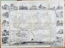
Black and white map of Marblehead MA with illustrations around it. Genuine-Map-Marblehead-1950-New-England-Map-Co-Maps-Of-Antiquity
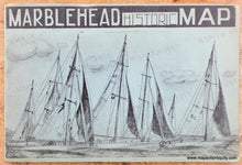
Paper cover of folded map. Blue-green with sailboats
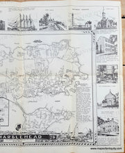
  • Load image into Gallery viewer, Black and white map of Marblehead MA with illustrations around it. Genuine-Map-Marblehead-1950-New-England-Map-Co-Maps-Of-Antiquity
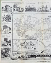
  • Load image into Gallery viewer, Black and white map of Marblehead MA with illustrations around it. Genuine-Map-Marblehead-1950-New-England-Map-Co-Maps-Of-Antiquity
  • Load image into Gallery viewer, Black and white map of Marblehead MA with illustrations around it. Genuine-Map-Marblehead-1950-New-England-Map-Co-Maps-Of-Antiquity
  • Load image into Gallery viewer, Paper cover of folded map. Blue-green with sailboats

1950 - Marblehead - Antique Map

Regular price
$175.00
Sale price
$175.00
Regular price
Sold out
Unit price
per 
Shipping calculated at checkout.

Item number: MAS2464

Genuine Map

1950

Maker: New England Map Co


Old map of Marblehead, Massachusetts, by the New England Map Co., 1950. A charmingly simple street map is surrounded by illustrations of notable buildings and events. An inset map features a suggested tour route through the town and a paragraph of text briefly outlines the history of the town. The title features a scene on the water in the background and the quote "This quaint old town is the yachting centre of the world." Issued folded with a paper jacket; jacket is still attached and can be folded under for framing. Very good condition with folds as issued and some mild toning along the folds. The outer paper jacket shows some mild signs of wear. Map measures approx. 13.5 x 19.5 inches to the neatline.

Genuine Map from 1950

Item Number: MAS2464