Current hours: 10am to 5pm Monday through Saturday. 12pm to 5pm Sundays. We are CLOSED on Christmas Day and New Years Day. We will close early (3pm) on Christmas Eve. IMPORTANT PLEASE NOTE: We have become aware that some of our photos have been stolen by other websites. Our maps are only available at our website www.mapsofantiquity.com or at our store!

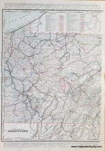
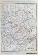
1900 Circa - Set Of Two Maps: Eastern Half Pennsylvania Western Antique Map Genuine
Genuine-Antique-Map-Set-of-two-maps-Eastern-Half-of-Pennsylvania-Western-Half-of-Pennsylvania-1900-circa-Cram-Grant-Maps-Of-Antiquity
  • Load image into Gallery viewer, 1900 Circa - Set Of Two Maps: Eastern Half Pennsylvania Western Antique Map Genuine
  • Load image into Gallery viewer, Genuine-Antique-Map-Set-of-two-maps-Eastern-Half-of-Pennsylvania-Western-Half-of-Pennsylvania-1900-circa-Cram-Grant-Maps-Of-Antiquity

1900 circa - Set of two maps: Eastern Half of Pennsylvania, Western Half of Pennsylvania - Antique Map

Regular price
$95.00
Sale price
$95.00
Regular price
Sold out
Unit price
per 
Shipping calculated at checkout.

Item number: MAT318
Genuine Antique Map

1900 circa

Maker: Cram / Grant

Set of two antique printed-color maps of Pennsylvania. These maps show all of the railroads in PA using a vibrant rainbow color-coded system. It is undated and lacking any publishing information, but it was likely published in Grant's Bankers' and Brokers' Atlas, 1892 published by Cram. Very good condition with some slight toning. Each map measures approximately 22.25" x 16.25" to the neatline.

Item Number: MAT318