Current hours: 10am to 5pm Tuesday through Saturday. We are closed Sundays and Mondays until late May. Proud to be a SMALL, LOCAL, CAPE COD BUSINESS! Maps of Antiquity is in its 38th year! Our maps are only available at our website www.mapsofantiquity.com or at our store!

Genuine-Antique-Map-Rand-McNally-Co-s-Map-of-the-Main-Portion-of-Baltimore-Verso-Maryland-and-Delaware-1895-Rand-McNally-Maps-Of-Antiquity
1895 - Rand, McNally & Co.'s Map of the Main Portion of Baltimore, Verso: Maryland and Delaware - Antique Map
  • Load image into Gallery viewer, Genuine-Antique-Map-Rand-McNally-Co-s-Map-of-the-Main-Portion-of-Baltimore-Verso-Maryland-and-Delaware-1895-Rand-McNally-Maps-Of-Antiquity
  • Load image into Gallery viewer, 1895 - Rand, McNally & Co.'s Map of the Main Portion of Baltimore, Verso: Maryland and Delaware - Antique Map

1895 - Rand, McNally & Co.'s Map of the Main Portion of Baltimore, Verso: Maryland and Delaware - Antique Map

Regular price
$45.00
Sale price
$45.00
Regular price
Sold out
Unit price
per 
Shipping calculated at checkout.

Item number: MAT333
Genuine Antique Map

1895

Maker: Rand McNally

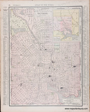
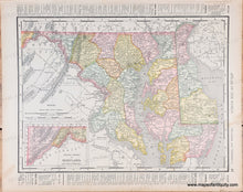
Antique printed color map of a central portion of Baltimore, Maryland with an inset map showing the overall outline of the city of Baltimore and noting the portion shown in the main map. Main map includes street names, railroads, and points of interest like Johns Hopkins University, Green Mount Cemetery, Druid Hill Park, etc. On Verso: Map of Maryland and Delaware, with the western portion of Maryland shown in an inset map. Includes railroads and some topographical detail. Published by Rand, McNally & Co., c. 1895. Very good antique condition with mild toning throughout, areas of soiling/staining mainly outside the neatline, and some minor edge wear/small tears at the outer edges. Map of Baltimore measures approximately 12.5" x 9.25" to the neatline. Verso Map measures approx. 9.25" x 12.5" to the neatline.

Genuine Antique Map from 1895

Item Number: MAT333