Genuine-Antique-Printed-Color-Comparative-Chart-Medo-Persian-Empire-showing-its-Twenty-Satrapies-B.C.-529-331;-verso:-Map-of-Ancient-Italy-Proper-B.C.-800-266-Map-of-Ancient-Egypt-B.C.-3000-A.D.-640-Middle-East-&-Holy-Land--1892-Home-Library-&-Supply-Association-Maps-Of-Antiquity-1800s-19th-century
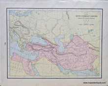
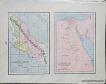
1892 - Medo-Persian Empire showing its Twenty Satrapies B.C. 529-331; verso: Map of Ancient Italy Proper B.C. 800-266, Map of Ancient Egypt B.C. 3000-A.D. 640 - Antique Chart
  • Load image into Gallery viewer, Genuine-Antique-Printed-Color-Comparative-Chart-Medo-Persian-Empire-showing-its-Twenty-Satrapies-B.C.-529-331;-verso:-Map-of-Ancient-Italy-Proper-B.C.-800-266-Map-of-Ancient-Egypt-B.C.-3000-A.D.-640-Middle-East-&-Holy-Land--1892-Home-Library-&-Supply-Association-Maps-Of-Antiquity-1800s-19th-century
  • Load image into Gallery viewer, 1892 - Medo-Persian Empire showing its Twenty Satrapies B.C. 529-331; verso: Map of Ancient Italy Proper B.C. 800-266, Map of Ancient Egypt B.C. 3000-A.D. 640 - Antique Chart

1892 - Medo-Persian Empire showing its Twenty Satrapies B.C. 529-331; verso: Map of Ancient Italy Proper B.C. 800-266, Map of Ancient Egypt B.C. 3000-A.D. 640 - Antique Chart

Regular price
$40.00
Sale price
$40.00
Regular price
Sold out
Unit price
per 
Shipping calculated at checkout.

Item number: MID202
Genuine Antique Printed Color Comparative Chart

1892

Maker: Home Library & Supply Association.

Antique printed color double-sided maps published in "The Pacific Coast and the World" by the Home Library and Supply Association, 1892. One side shows Medo-Persian Empire showing its Twenty Satrapies B.C. 529-331; the other side has a Map of Ancient Italy Proper B.C. 800-266 and a Map of Ancient Egypt B.C. 3000-A.D. 640. Very good overall antique condition with some very mild toning/foxing (mainly at the outer edges.) Larger map measures approx. 12 x 9" to the neatline, smaller maps measure approx. 8.5 x 5.5 inches to the neatline.

Item Number: MID202