Current hours: 10am to 5pm Monday through Saturday. Closed on Sundays. PLEASE NOTE: Our maps are only available at our website www.mapsofantiquity.com or at our store!

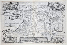
1744 - Middle East & Holy Land - De Gelegentheyt Van't Paradys En't Landt Canaan. Mitsgaders D'eerst bewoonde Landen der Patriachen uyt de H. Schristure... (Paradise) - Antique Map

1744 - Middle East & Holy Land - De Gelegentheyt Van't Paradys En't Landt Canaan. Mitsgaders D'eerst bewoonde Landen der Patriachen uyt de H. Schristure... (Paradise) - Antique Map

Regular price
$350.00
Sale price
$350.00
Regular price
Sold out
Unit price
per 
Shipping calculated at checkout.

Item number: MID207
Genuine Antique Uncolored Map

c. 1730/1744

Maker: Jan van Jagen / Stoopendaal


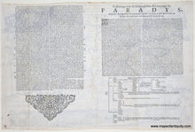
Antique uncolored map of the Middle East, including part of Egypt and the Holy Land (comprised of Israel, Lebanon, and Jordan), by Jan van Jagen after Daniel Stoopendaal, 1744. From the Dutch so-called ' Staten' bibles, published between 1637 and c. 1760, which contained 5 maps: The World, ' Paradise', The Perigrinations, The Promised Land Canaan, The Travels of St. Paul and a plan of Jerusalem. Vignettes depict the story of Adam and Eve with an image of Noah's Ark confined in a decorative border at lower center. The Keur publishing family used Daniel Stoopendaal's maps for 70 years in their Bibles. When the plate became worn, Jan van Jagen was commissioned to engrave a new plate. This version may have been created as early as 1730 based on the size and image, and this particular example was printed in 1744. Very good restored condition, with repaired seam separations and some minor toning along outer fold lines and paper edges. Despite the imperfections this map is pleasing and worthy of ownership. Map has been archivally cleaned, deacidified, repaired, and backed. Approx. 12 x 17.5 inches to the neatline.


Model Number: MID207