Current hours: 10am to 5pm Monday through Saturday. 12pm to 5pm Sundays. We are CLOSED on Christmas Day and New Years Day. We will close early (3pm) on Christmas Eve. IMPORTANT PLEASE NOTE: We have become aware that some of our photos have been stolen by other websites. Our maps are only available at our website www.mapsofantiquity.com or at our store!

Genuine-Antique-Chart-Fragment-of-Captain-Hollands-A-new-and-correct-chart-of-the-coast-of-New-England-and-New-York-with-the-adjacent-parts-of-Nova-Scotia-and-New-Brunswick-from-Cape-Sable-to-the-entrance-of-Hudsons-or-North-River-1799-circa-Laurie-Whittle-Maps-Of-Antiquity
  • Load image into Gallery viewer, Genuine-Antique-Chart-Fragment-of-Captain-Hollands-A-new-and-correct-chart-of-the-coast-of-New-England-and-New-York-with-the-adjacent-parts-of-Nova-Scotia-and-New-Brunswick-from-Cape-Sable-to-the-entrance-of-Hudsons-or-North-River-1799-circa-Laurie-Whittle-Maps-Of-Antiquity
  • Load image into Gallery viewer, Genuine-Antique-Chart-Fragment-of-Captain-Hollands-A-new-and-correct-chart-of-the-coast-of-New-England-and-New-York-with-the-adjacent-parts-of-Nova-Scotia-and-New-Brunswick-from-Cape-Sable-to-the-entrance-of-Hudsons-or-North-River-1799-circa-Laurie-Whittle-Maps-Of-Antiquity

1799 (circa) - Fragment of Captain Holland's A new and correct chart of the coast of New England and New York with the adjacent parts of Nova Scotia and New Brunswick from Cape Sable to the entrance of Hudsons or North River - Antique Map

Regular price
$650.00
Sale price
$650.00
Regular price
Sold out
Unit price
per 
Shipping calculated at checkout.

Item number: NAU443
Genuine Antique Chart

1799 (circa)

Maker: Laurie & Whittle


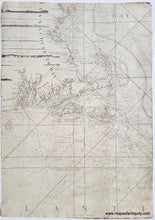
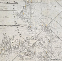
Stunning fragment of a nautical chart by Captain Holland and published by Laurie & Whittle c.1799. There are several extant charts that are part of famous collections, such as the Leventhal Collection at Boston Public Library. The date on their listing is 1794, however we have noticed small differences between our chart and theirs, which suggests ours is slightly later. In 1797, a station authorized by George Washington was established in Truro on Cape Cod, with a wood lighthouse to warn ships about the dangerous coastline between Cape Ann and Nantucket. It was the first lighthouse on Cape Cod. Our chart shows that lighthouse and includes a notation on the landmass south of Plymouth with information about "The Light of Cape Cod." Hand-coloring was added to mark the lighthouses but we believe it was added later, as it marks the locations of other lighthouses that are not included on the printed chart. This fragment includes Block Island, Narragansett Bay, Martha's Vineyard, Nantucket, Cape Cod, Plymouth, Boston, Salem and Marblehead, and Cape Ann. Some interesting details include "Crab Bank" along the east of Cape Cod, interesting spellings of some locations (Cohasset is Konohasset and Nauset is Nursset), and seven partial recognition profiles on the left side. The barrier beaches of Chatham are shown almost like shoals and there is a note that says "Old Entrance 30 Years ago." Good to very good condition with minor spots and soil, and some small areas of surface loss, including a scratched out area under the notation about the Light of Cape Cod, where someone scratched the surface off the chart to remove the text. Measures approx. 19.25 x 13.5 inches to the paper edges.


Item Number: NAU443