Current hours: 10am to 5pm Tuesday through Saturday. We are closed Sundays and Mondays for the Winter. IMPORTANT PLEASE NOTE: We have become aware that some of our photos have been stolen by other websites. Our maps are only available at our website www.mapsofantiquity.com or at our store!

Antique-Hand-Colored-Map-New-Driving-Road-Map-of-Essex-County-Mass.-United-States-Massachusetts-1884-Walker-Maps-Of-Antiquity
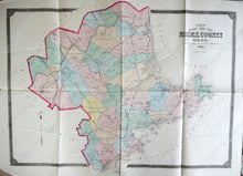
1884 - New Driving Road Map Of Essex County Mass. Antique Genuine Hand-Colored
  • Load image into Gallery viewer, Antique-Hand-Colored-Map-New-Driving-Road-Map-of-Essex-County-Mass.-United-States-Massachusetts-1884-Walker-Maps-Of-Antiquity
  • Load image into Gallery viewer, 1884 - New Driving Road Map Of Essex County Mass. Antique Genuine Hand-Colored
  • Load image into Gallery viewer, 1884 - New Driving Road Map Of Essex County Mass. Antique Genuine Hand-Colored

1884 - New Driving Road Map of Essex County Mass. - Antique Map

Regular price
$225.00
Sale price
$225.00
Regular price
Sold out
Unit price
per 
Shipping calculated at checkout.

Item number: MAS1638
Genuine Antique Hand Colored Map

1884

Maker: Walker.

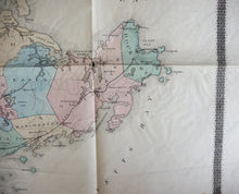
Antique hand colored map of Essex County in Massachusetts from Walker's 1884 Atlas of Essex County. Includes Lynn, Saugus, Salem, Marblehead, Swampscott, Peabody, Manchester, Gloucester, Rockport, Essex, Ipswich, Rowley, Newbury, Newburyport, Salisbury, Amesbury, Andover, and more. Shows villages, local areas, bodies of water, islands, railroads, major roads, and features a decorative border. Good antique condition with some light staining and foxing, some damage at edges outside border, and small seam separations that can be repaired. approx. 25 x 32 inches.

Item Number: MAS1638