1874
Maker: Beers.
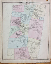
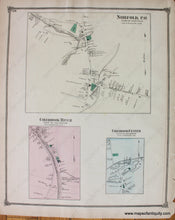
Antique hand colored map of the Town of Norfolk, Connecticut, from F.W. Beers' County Atlas of Litchfield, 1874, with districts and other villages of the time delineated by color, showing major roads, railroads, property owners, schools, churches, cemeteries, businesses, rivers, lakes, and the Norfolk Granite Quarry. Verso displays village plans of Norfolk, Colebrook River and Colebrook Center, the latter two in the Town of Colebrook. Very good antique condition with overall toning, measures approx. 14 x 11.5 inches. Paper is fragile.
Item Number: CON309


