Current hours: 10am to 5pm Monday through Saturday. 12pm to 5pm Sundays. IMPORTANT PLEASE NOTE: We have become aware that some of our photos have been stolen by other websites. Our maps are only available at our website www.mapsofantiquity.com or at our store!

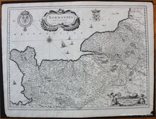
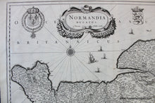
1640 - Normandy, France - Normandia Ducatus - Antique Map
  • Load image into Gallery viewer, 1640 - Normandy, France - Normandia Ducatus - Antique Map
  • Load image into Gallery viewer, 1640 - Normandy, France - Normandia Ducatus - Antique Map

1640 - Normandy, France - Normandia Ducatus - Antique Map

Regular price
$350.00
Sale price
$350.00
Regular price
Sold out
Unit price
per 
Shipping calculated at checkout.

Item number: EUR2703
Genuine Antique Map

c. 1640

Maker: Hondius.


Antique uncolored map of  Normandy, France by Hondius, c. 1640. This map shows cities, towns, rivers, forests, and more. Includes ships and sea monsters, a compass rose, crests, and decorative cartouche and scale of miles. Very good restored condition - map has been cleaned and deacidified. Measures approx. 15 x 20.5 inches to the neatline.


Item Number: EUR2703