Current hours: 10am to 5pm Monday through Saturday. Closed on Sundays. PLEASE NOTE: Our maps are only available at our website www.mapsofantiquity.com or at our store!

Genuine-Antique-Hand-colored-Folding-Map-Map-of-Part-of-the-Thousand-Islands-of-the-St-Lawrence-River-near-Alexandria-Bay-N-Y--1879-Rockwell-Maps-Of-Antiquity
  • Load image into Gallery viewer, Genuine-Antique-Hand-colored-Folding-Map-Map-of-Part-of-the-Thousand-Islands-of-the-St-Lawrence-River-near-Alexandria-Bay-N-Y--1879-Rockwell-Maps-Of-Antiquity
  • Load image into Gallery viewer, Genuine-Antique-Hand-colored-Folding-Map-Map-of-Part-of-the-Thousand-Islands-of-the-St-Lawrence-River-near-Alexandria-Bay-N-Y--1879-Rockwell-Maps-Of-Antiquity
  • Load image into Gallery viewer, Genuine-Antique-Hand-colored-Folding-Map-Map-of-Part-of-the-Thousand-Islands-of-the-St-Lawrence-River-near-Alexandria-Bay-N-Y--1879-Rockwell-Maps-Of-Antiquity
  • Load image into Gallery viewer, Genuine-Antique-Hand-colored-Folding-Map-Map-of-Part-of-the-Thousand-Islands-of-the-St-Lawrence-River-near-Alexandria-Bay-N-Y--1879-Rockwell-Maps-Of-Antiquity

1879 - Map of Part of the Thousand Islands of the St Lawrence River near Alexandria Bay, N.Y. - Antique Map

Regular price
$975.00
Sale price
$975.00
Regular price
Sold out
Unit price
per 
Shipping calculated at checkout.

Item number: NYO1035
Genuine Antique Hand-colored Folding Map

1879

Maker: Rockwell


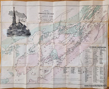
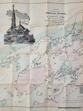
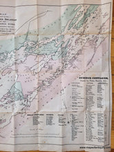
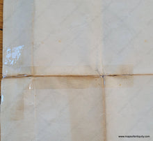
Antique hand-colored folding map of part of the Thousand Islands in the St Lawrence River between New York and Canada, published by George Rockwell in 1879. This rare publication is the second edition of the map, the first edition being smaller and more limited in area and published in 1875. The map was created based on the surveys of Captain Owens of 1818. This map is attached to its original jacket, which includes a message to the public written by Rockwell explaining the creation of the map. There is also a note that the arrow indicating north was accidentally added on the wrong way- it should be parallel with the vertical border lines with north on the map being directly up. This map includes an image of the cathedral in Wellesley Park, a list of American Summer Hotels, and a list of summer cottages and their owners. Locations marked on the map include towns, railroads, lighthouses, hotels, homes, roads, marshes, and more. This map is in original condition with wear and small separations along the folds, and some plastic tape on the back side on the right. Could be archivally restored for an additional cost. Measures approx. 17.25 x 23.25 inches to the neatline.


Item Number: NYO1035