UNFRAMED MAPS should be ordered PRIOR TO Thursday, DECEMBER 19th for arrival by December 25th (December 13th deadline for Hawaii). We are past the deadline for orders with custom framing unless you will be picking up. Current hours: 10am to 5pm Monday through Saturday. 12pm to 5pm Sundays. IMPORTANT PLEASE NOTE: We have become aware that some of our photos have been stolen by other websites. Our maps are only available at our website www.mapsofantiquity.com or at our store!

Framed-Genuine-Antique-Map-Fannings-Map-of-New-York-shewing-the-entire-Island-with-the-Cities-of-Brooklyn-and-Jersey-City-1856-Ensign,-Bridgman-&-Fanning-Maps-Of-Antiquity
  • Load image into Gallery viewer, Framed-Genuine-Antique-Map-Fannings-Map-of-New-York-shewing-the-entire-Island-with-the-Cities-of-Brooklyn-and-Jersey-City-1856-Ensign,-Bridgman-&-Fanning-Maps-Of-Antiquity
  • Load image into Gallery viewer, Framed-Genuine-Antique-Map-Fannings-Map-of-New-York-shewing-the-entire-Island-with-the-Cities-of-Brooklyn-and-Jersey-City-1856-Ensign,-Bridgman-&-Fanning-Maps-Of-Antiquity
  • Load image into Gallery viewer, Framed-Genuine-Antique-Map-Fannings-Map-of-New-York-shewing-the-entire-Island-with-the-Cities-of-Brooklyn-and-Jersey-City-1856-Ensign,-Bridgman-&-Fanning-Maps-Of-Antiquity
  • Load image into Gallery viewer, Framed-Genuine-Antique-Map-Fannings-Map-of-New-York-shewing-the-entire-Island-with-the-Cities-of-Brooklyn-and-Jersey-City-1856-Ensign,-Bridgman-&-Fanning-Maps-Of-Antiquity
  • Load image into Gallery viewer, Framed-Genuine-Antique-Map-Fannings-Map-of-New-York-shewing-the-entire-Island-with-the-Cities-of-Brooklyn-and-Jersey-City-1856-Ensign,-Bridgman-&-Fanning-Maps-Of-Antiquity

1856 - Fanning's Map of New York shewing the entire Island with the Cities of Brooklyn and Jersey City - Antique Map

Regular price
$1,500.00
Sale price
$1,500.00
Regular price
Sold out
Unit price
per 
Shipping calculated at checkout.

Item number: NYO1020
Framed Genuine Antique Map

1856

Maker: Ensign, Bridgman & Fanning


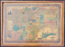
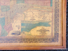
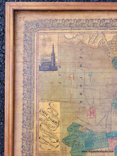
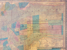
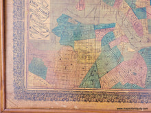
Rare and nearly unknown edition of Fanning's wall map of New York City, published by Ensign, Bridgman & Fanning, c. 1856. This map shows Manhattan and Brooklyn as they were in the mid-1800s. Central park was approved in 1853 but it wasn't until 1857 that Olmsted and Vaux won the design competition, which is why Central Park on this map is shown but it's design unknown. In the lower right corner is an inset showing the Northern Part of New York. There are also two illustrations included on the map: Trinity Church (the current church building was erected from 1839 to 1846 and was the tallest building in the United States until 1869, as well as the tallest in New York City until 1890), and High Bridge (the oldest bridge in modern New York City, having originally opened as part of the Croton Aqueduct in 1848). This map delineates wards and districts using colored lines and areas. It features a highly decorative border. This map was mounted on fabric and varnished. It is currently mounted on a board. It is in fair to good antique condition with some minor abrasions to the surface tears that are not significant because it is mounted. It may be possible to restore the map nicely but it can also be enjoyed as it is. It is currently framed in an old 20th century frame with no glass, and we recommend having it reframed, or having UV protective glass added to this frame. Measures approx. 19.75 x 29.25 inches to the map neatline not including the decorative border. Total dimensions including the frame are 27 x36.5 inches. **NOTE- because this map requires extra insurance for shipping, an additional charge will appear on your card after your original purchase. If you would like to know what that charge will be, please contact us. If you would prefer to have the map shipped unframed, which will save on shipping, please let us know (price does not change if map is sold without the framing)**


Item Number: NYO1020