1892
Maker: Home Library & Supply Association.
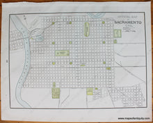
Antique printed color city map of Oakland, California (Recto.) Map is detailed showing overview of city blocks, names of major streets, cable railroads, horse roads, and proposed electric railroads, etc. Verso: Map of Sacramento, California which shows overview of city blocks, names of major city streets, city railways, proposed railways, and points of interest (e.g. parks, cemeteries, plazas, etc.) Published in "The Pacific Coast and the World" by the Home Library and Supply Association, 1892. Both maps are in very good overall antique condition with some very mild toning/foxing (mainly at the outer edges,) as well as mild overall wrinkling of the paper. Recto Map (Oakland) Measures approximately 13" x 9" (H x W) to the neatline. Verso Map (Sacramento) measures approx. 9" x 13" to the neatline.
Item Number: WES292


