1900
Maker: Baschet / Lokay.
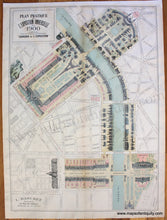
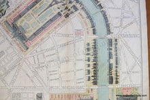
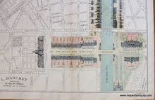
Antique printed color pictorial map of the Exposition Universelle of 1900, better known in English as the 1900 Paris Exposition. This was a world's fair held in Paris, France, from 14 April to 12 November 1900, to celebrate the achievements of the past century and to accelerate development into the next. This rare and unusual map was designed by H. Lokay and published by L. Baschet. It features illustrations of the buildings involved in the exposition in a unique way- each building has been turned on its back so that you can see its front facing in the direction it faces to the road! The map focuses on the Seine River and displays careful detail to all of the facades pictured. Includes the Eiffel Tower, which was finished in 1889 and was originally permitted to stay for only 20 years before it was to be dismantled. For the 1900 Exposition Universelle, the lifts in the east and west legs were replaced by lifts running as far as the second level. It is labeled Tour de 300 Metres on this map. Very good restored condition- map has been cleaned, deacidified, backed with light-weigh paper for structural integrity. Some minor signs of age remain, mostly in the margin. Slight waviness of the paper. Measures approx. 26.5 x 19 inches to the neatline. **NOTE- because this map requires extra insurance for shipping, an additional charge will appear on your card after your original purchase. If you would like to know what that charge will be, please contact us.**
Item Number: EUR2676


