Current hours: 10am to 5pm Monday through Saturday and 12-5 on Sundays. Proud to be a SMALL, LOCAL, CAPE COD BUSINESS! Maps of Antiquity is in its 38th year! Our maps are only available at our website www.mapsofantiquity.com or at our store!

Antique-Printed-Color-Map-Principal-Cities-of-The-Old-World-Comparing-Their-Latitude-with-Points-on-The-American-Continent-verso:-Turkish-Empire-in-Europe-and-Asia-Towns-and-City-Maps-Europe-Turkey-1900-Cram-Maps-Of-Antiquity
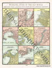
1900 - Principal Cities Of The Old World Comparing Their Latitude With Points On American Continent
  • Load image into Gallery viewer, Antique-Printed-Color-Map-Principal-Cities-of-The-Old-World-Comparing-Their-Latitude-with-Points-on-The-American-Continent-verso:-Turkish-Empire-in-Europe-and-Asia-Towns-and-City-Maps-Europe-Turkey-1900-Cram-Maps-Of-Antiquity
  • Load image into Gallery viewer, 1900 - Principal Cities Of The Old World Comparing Their Latitude With Points On American Continent

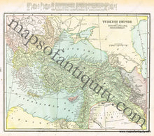
1900 - Principal Cities of The Old World, Comparing Their Latitude with Points on The American Continent, verso: Turkish Empire in Europe and Asia - Antique Map

Regular price
$40.00
Sale price
$40.00
Regular price
Sold out
Unit price
per 
Shipping calculated at checkout.

Item number: TOW382
Genuine Antique Printed Color Map

1900

Maker: Cram.

Antique printed color page of maps of principal cities (Recto). Features Venice, Geneva, Marseille, Genoa, Athens, Constantinople, Alexandria, Gibraltar, and Cairo. Also includes the latitudes and longitudes of each city. Verso: A map of the Turkish Empire as it existed at the time (Map published in 1900), in both Europe and Asia. Includes the area, population, and chief cities of the portion of Turkey in Asia. Very good condition with some mild toning at the edges of the page. By Cram, in Cram's Universal Atlas Geographical, Astronomical and Historical, 1900. Recto map measures approximately 11.75" x 9" to the neatline. Verso map measures approx. 9.75" x 12" to the neatline.

Item Number: TOW382