1900
Maker: Cram.
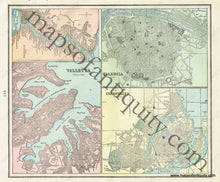
Antique double-sided printed color map of Rome, Italy (Recto). Includes names of streets, bodies of water, and some points of interest. Verso: A map of Valencia (Spain), a map of Copenhagen (Denmark), a map of Valletta (Island of Malta), and a map of The Bosphorus (a strait in Northwestern Turkey). Any of the verso maps may be separated from the others, if desired. All of the verso city maps include city streets/blocks and some points of interest. The verso map of The Bosphorus also includes the nearby cities/towns and some points of interest. Very good condition with some slight toning at the edges of the page. By Cram, in Cram's Universal Atlas Geographical, Astronomical and Historical, 1900. Recto map (Rome, Italy) measures approximately 9.5" x 12" to the neatline. Map of Valencia measures approx. 4.75" x 6.25" to the neatline. Map of Copenhagen measures approx. 5.25" x 6.25" to the neatline. Map of Valletta measures approx. 6.75" x 5.25" to the neatline. Map of The Bosphorus measures approx. 5.25" x 3.25" to the neatline.
Item Number: EUR1898


