Current hours: 10am to 5pm Monday through Saturday. 12pm to 5pm Sundays. We are CLOSED on Christmas Day and New Years Day. We will close early (3pm) on Christmas Eve. IMPORTANT PLEASE NOTE: We have become aware that some of our photos have been stolen by other websites. Our maps are only available at our website www.mapsofantiquity.com or at our store!

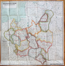
Genuine-Antique-Map-Rzeczpospolita-Polska---The-Republic-of-Poland-Europe-Poland-1923-The-Geographical-Publishing-Co.-Maps-Of-Antiquity-1800s-19th-century
1923 - Rzeczpospolita Polska The Republic Of Poland Antique Map Genuine
  • Load image into Gallery viewer, Genuine-Antique-Map-Rzeczpospolita-Polska---The-Republic-of-Poland-Europe-Poland-1923-The-Geographical-Publishing-Co.-Maps-Of-Antiquity-1800s-19th-century
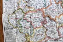
  • Load image into Gallery viewer, 1923 - Rzeczpospolita Polska The Republic Of Poland Antique Map Genuine
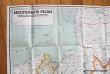
  • Load image into Gallery viewer, 1923 - Rzeczpospolita Polska The Republic Of Poland Antique Map Genuine

1923 - Rzeczpospolita Polska - The Republic of Poland - Antique Map

Regular price
$125.00
Sale price
$125.00
Regular price
Sold out
Unit price
per 
Shipping calculated at checkout.

Item number: EUR2710
Genuine Antique Map

1923

Maker: The Geographical Publishing Co..

Antique printed color folding map of Poland, by the Geographical Publishing Co., 1923. This map shows the Administratove Division of the Republic of Poland into Voivodeships and Countries, according to the title above the text in the lower left. Includes towns, cities, railroads, roads, swamps, canals, and villages. Map is in Polish. Fair to good condition with fold as issued and some wear along the folds including separations on some of the fold lines. Measures approx. 32.5 x 31.75 inches.

Item Number: EUR2710