Winter hours: Tuesday - Saturday 10am to 5pm. Close Sundays and Mondays until May. We appreciate your business!

Antique-Printed-Color-Railroad-Map-Summer-Resorts-of-the-Coast-Lake-and-Mountain-Regions-along-the-Boston-&-Maine-Railroad-and-Connections-**********-United-States-Northeast-1915-Matthews-Northrup-Works-Maps-Of-Antiquity
  • Load image into Gallery viewer, Antique-Printed-Color-Railroad-Map-Summer-Resorts-of-the-Coast-Lake-and-Mountain-Regions-along-the-Boston-&-Maine-Railroad-and-Connections-**********-United-States-Northeast-1915-Matthews-Northrup-Works-Maps-Of-Antiquity
  • Load image into Gallery viewer, Antique-Printed-Color-Railroad-Map-Summer-Resorts-of-the-Coast-Lake-and-Mountain-Regions-along-the-Boston-&-Maine-Railroad-and-Connections-**********-United-States-Northeast-1915-Matthews-Northrup-Works-Maps-Of-Antiquity
  • Load image into Gallery viewer, Antique-Printed-Color-Railroad-Map-Summer-Resorts-of-the-Coast-Lake-and-Mountain-Regions-along-the-Boston-&-Maine-Railroad-and-Connections-**********-United-States-Northeast-1915-Matthews-Northrup-Works-Maps-Of-Antiquity

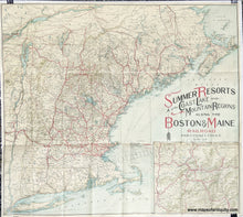
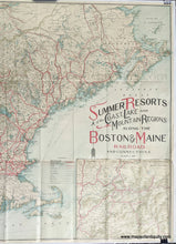
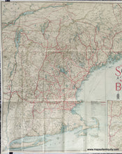
1909 - Summer Resorts of the Coast, Lake, and Mountain Regions along the Boston & Maine Railroad and Connections - Antique Railroad Map

Regular price
$285.00
Sale price
$285.00
Regular price
Sold out
Unit price
per 
Shipping calculated at checkout.

Item number: NEW124
Genuine Antique Printed Color Railroad Map

1909

Maker: Matthews-Northrup Works.


Antique printed color railroad map of New England by the Matthews-Northrup Works, 1909. This map shows all of New England- Connecticut, Rhode Island, Massachusetts, Vermont, New Hampshire, and Maine, as well as parts of Canada and New York. Inset map features "The American Switzerland" as reached by the Boston & Maine R.R., which is the vicinity of the White Mountains. Very good condition, with folds as issued and minor wear at folds and fold intersections. Approx. 25.5 x 28.5 inches to the neatline.  


Item Number: NEW124