Current hours: 10am to 5pm Monday through Saturday. 12pm to 5pm Sundays. We are CLOSED on Christmas Day and New Years Day. We will close early (3pm) on Christmas Eve. IMPORTANT PLEASE NOTE: We have become aware that some of our photos have been stolen by other websites. Our maps are only available at our website www.mapsofantiquity.com or at our store!

Antique-Printed-Color-Map-Texas-Eastern-Part-c.-1880-Cram-South-Texas-1800s-19th-century-Maps-of-Antiquity
1880 - Texas Eastern Part Antique Map Genuine Printed-Color
  • Load image into Gallery viewer, Antique-Printed-Color-Map-Texas-Eastern-Part-c.-1880-Cram-South-Texas-1800s-19th-century-Maps-of-Antiquity
  • Load image into Gallery viewer, 1880 - Texas Eastern Part Antique Map Genuine Printed-Color
  • Load image into Gallery viewer, 1880 - Texas Eastern Part Antique Map Genuine Printed-Color

1880 - Texas Eastern Part - Antique Map

Regular price
$95.00
Sale price
$95.00
Regular price
Sold out
Unit price
per 
Shipping calculated at checkout.

Item number: SOU439
Genuine Antique Printed Color Map

c. 1880

Maker: Cram.

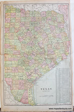
Antique printed color map of the eastern half of Texas by Cram, c. 1880. This map is colored by county and shows cities, towns, railroads, etc. Includes Dallas, Fort Worth, Austin, Waco, Houston, Corpus Christi, Galveston, and more. Text on the lower right lists counties and chief cities. Good to very good antique condition with some mild spots, minor toning, and some small tears at the paper edges including one tear just barely into the map on the left side (the tape on the back side does not appear to be archival). Approx. 20.5 x 13.25 inches to the neatline.

Item Number: SOU439