Current hours: 10am to 5pm Tuesday through Saturday. We are closed Sundays and Mondays until late May. Proud to be a SMALL, LOCAL, CAPE COD BUSINESS! Maps of Antiquity is in its 38th year! Our maps are only available at our website www.mapsofantiquity.com or at our store!

Printed-Color-Pictorial-Map-The-Prudential-Map-of-Discovery-and-Exploration-1000-1961-1961-General-Drafting-Co.-1900s-20th-century-Maps-of-Antiquity
1961 - The Prudential Map Of Discovery And Exploration 1000-1961 Antique Pictorial Printed-Color
  • Load image into Gallery viewer, Printed-Color-Pictorial-Map-The-Prudential-Map-of-Discovery-and-Exploration-1000-1961-1961-General-Drafting-Co.-1900s-20th-century-Maps-of-Antiquity
  • Load image into Gallery viewer, 1961 - The Prudential Map Of Discovery And Exploration 1000-1961 Antique Pictorial Printed-Color
  • Load image into Gallery viewer, 1961 - The Prudential Map Of Discovery And Exploration 1000-1961 Antique Pictorial Printed-Color
  • Load image into Gallery viewer, 1961 - The Prudential Map Of Discovery And Exploration 1000-1961 Antique Pictorial Printed-Color

1961 - The Prudential Map of Discovery and Exploration 1000-1961 - Antique Pictorial Map

Regular price
$95.00
Sale price
$95.00
Regular price
Sold out
Unit price
per 
Shipping calculated at checkout.

Item number: WOR300
Printed Color Pictorial Map

1961

Maker: General Drafting Co. .

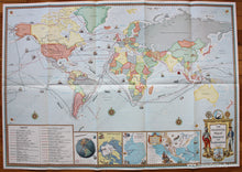
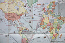
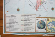
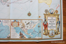
Printed color pictorial map of the world showing the routes of many explorers, published in 1961 by the General Drafting Company. Small illustrations are scattered throughout, including ships, submarines, sea monsters, the winds, and several compass roses. A list of the explorers can be found in the lower left with their highlights described. These include Drake, Hudson, Leif Ericsson, Cook, De Gama, Columbus, Amundsen, Vespucci, Magellan, and many more. Other inset maps include explorations of the North and South Poles, early Spanish and French explorations in North America, and early satellites. Very good condition with folds as issued. Measures approx. 25 x 36 inches to the paper edges.

Item Number: WOR300