Current hours: 10am to 5pm Monday through Saturday. Closed on Sundays. PLEASE NOTE: Our maps are only available at our website www.mapsofantiquity.com or at our store!

Genuine-Antique-Topographical-Map-Island-of-Molokai-Hawaii-Topo-Map-1952-USGS-U-S--Geological-Survey-Maps-Of-Antiquity
  • Load image into Gallery viewer, Genuine-Antique-Topographical-Map-Island-of-Molokai-Hawaii-Topo-Map-1952-USGS-U-S--Geological-Survey-Maps-Of-Antiquity
  • Load image into Gallery viewer, Genuine-Antique-Topographical-Map-Island-of-Molokai-Hawaii-Topo-Map-1952-USGS-U-S--Geological-Survey-Maps-Of-Antiquity
  • Load image into Gallery viewer, Genuine-Antique-Topographical-Map-Island-of-Molokai-Hawaii-Topo-Map-1952-USGS-U-S--Geological-Survey-Maps-Of-Antiquity

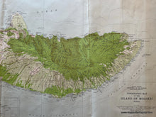
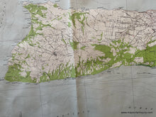
1952 - Island of Molokai Hawaii Topo Map - Antique Map

Regular price
$150.00
Sale price
$150.00
Regular price
Sold out
Unit price
per 
Shipping calculated at checkout.

Item number: TOP100
Genuine Antique Topographical Map

1952

Maker: USGS/U.S. Geological Survey

Antique topographic map of the Island of Mokai Hawaii including Mauna Loa, Kaluakoi, Kaluapapa, Molokai Forest Reserve and much more. Good detail and in fair to good antique condition with some edge wear and shadows from discoloration/toning and minor staining, some creasing. The sheet size measures approximately 21"h x 47"w.

Item Number: TOP100