Antique-Printed-Color-Map-United-Kingdom-of-Great-Britain-and-Ireland-1848-Goodrich-Great-Britian-1800s-19th-century-Maps-of-Antiquity
1848 - United Kingdom of Great Britain and Ireland - Antique Map
  • Load image into Gallery viewer, Antique-Printed-Color-Map-United-Kingdom-of-Great-Britain-and-Ireland-1848-Goodrich-Great-Britian-1800s-19th-century-Maps-of-Antiquity
  • Load image into Gallery viewer, 1848 - United Kingdom of Great Britain and Ireland - Antique Map

1848 - United Kingdom of Great Britain and Ireland - Antique Map

Regular price
$30.00
Sale price
$30.00
Regular price
Sold out
Unit price
per 
Shipping calculated at checkout.

Item number: EUR2468
Genuine Antique Printed Color Map

1848

Maker: Goodrich.

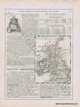
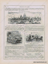
Antique early printed color outlined two-sided page from A National Geography for Schools written by S.G. Goodrich and published by Huntington and Savage in 1848, including engravings of Queen Victoria, a View of the City of London with St. Paul's Church, Boats on the Thames, Buckingham Palace, and the Queen's Coach and Guard, with text and tables describing the region, etc. In very good antique condition with minor toning, foxing and general signs of age, page measures approximately 10.5 x 8.5 inches.

Item Number: EUR2468