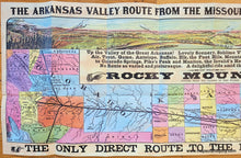
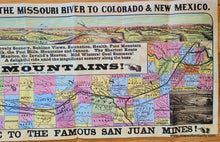
Vintage-Facsimile-of-an-Antique-Map-The-Arkansas-Valley-Route-From-The-Missouri-River-To-Colorado-New-Mexico-1876-1940s-Woodward-Tiernan-Printing-Company-Maps-Of-Antiquity
  • Load image into Gallery viewer, Vintage-Facsimile-of-an-Antique-Map-The-Arkansas-Valley-Route-From-The-Missouri-River-To-Colorado-New-Mexico-1876-1940s-Woodward-Tiernan-Printing-Company-Maps-Of-Antiquity
  • Load image into Gallery viewer, Vintage-Facsimile-of-an-Antique-Map-The-Arkansas-Valley-Route-From-The-Missouri-River-To-Colorado-New-Mexico-1876-1940s-Woodward-Tiernan-Printing-Company-Maps-Of-Antiquity
  • Load image into Gallery viewer, Vintage-Facsimile-of-an-Antique-Map-The-Arkansas-Valley-Route-From-The-Missouri-River-To-Colorado-New-Mexico-1876-1940s-Woodward-Tiernan-Printing-Company-Maps-Of-Antiquity
  • Load image into Gallery viewer, Vintage-Facsimile-of-an-Antique-Map-The-Arkansas-Valley-Route-From-The-Missouri-River-To-Colorado-New-Mexico-1876-1940s-Woodward-Tiernan-Printing-Company-Maps-Of-Antiquity

1876/1940s - The Arkansas Valley Route From The Missouri River To Colorado & New Mexico - Antique Map

Regular price
$250.00
Sale price
$250.00
Regular price
Sold out
Unit price
per 
Shipping calculated at checkout.

Item number: WES479
Vintage Facsimile of an Antique Map

1876/1940s

Maker: Woodward & Tiernan Printing Company


Antique facsimile of a rare railroad pamphlet from 1876- this recreation was probably printed around 1940. On one side is the railroad route from the Missouri River to Colorado with a lovely bird's eye view at the top in vibrant color. On the back is information about the route, including sights you would see from the train. Even as a facsimile from the 20th century, this is a relatively rare map. Very few are available. This map is in very good condition with some wear along the folds and small tears at the bottom and right sides. Measures approx. 13 x 36 inches to the paper edges.


Item Number: WES479