Genuine Antique Map
1633 (circa)
Maker: Mercator
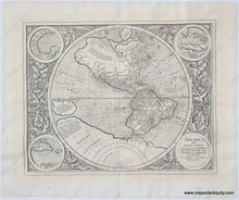
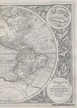
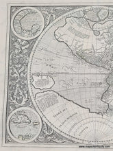
Antique map of the Western Hemisphere originally made by Michael Mercator in 1595 and published at various times. Michael Mercator was the grandson of Gerald Mercator, the well-known cartography. This is the only known map that Michael Mercator ever produced. The printing plates were purchased by Jodocus Hondius in 1606 and he reissued the atlas from Amsterdam. His sons, Jodocus II and Henricus continued with the publication of the maps until 1629 when a large number of the plates were sold to Willem Janszoon Blaeu. We believe this map to be from the 1633, 1635, or 1639 edition of Atlantis Pars Altera. Text of map in Latin; text on verso in French with page numbers 72 and 69. Largely based on Mercator's world map of 1587, this map aptly reflects 16th-century knowledge, theories and suppositions regarding the New World. Naturally, most of this new knowledge was coastal, and configurations of any large areas were greatly hampered by the lack of a sound means of determining longitude. "A few of the most famous theories are still present: a large inland lake in Canada, two of the four islands of the North Pole, a bulge to the west coast of South America and the large southern continent" (Burden). California is correctly shown as a peninsula, and the "Mare dulcium aquarum" probably reflects the first hints of the Great Lakes. Small roundels depicting Cuba, Haiti, the Gulf of Mexico rest amid a decorative border of cornucopias and acanthus leaves. This map has been archivally cleaned, deacidified, and backed. Some small vestiges of its original color remain, and this map could be hand colored by our professional colorist for an additional cost. Very good overall condition with some repaired tears and wrinkles still mildly visible. Paper is slightly wavy. Excellent print impression. Measures approx. 14.5 x 18 inches to the neatline.
Item Number: WOR389


